Home
About Us
Our Team
License
Major Milestones
Services
1- Artificial Intelligence (AI) to assist Material Corrosion Inspection (MCI), Hook Up & Commissioning (HUC) works and Assets Integrity Management (AIM)
2- Reverse Engineering & Building Information Modelling (BIM)
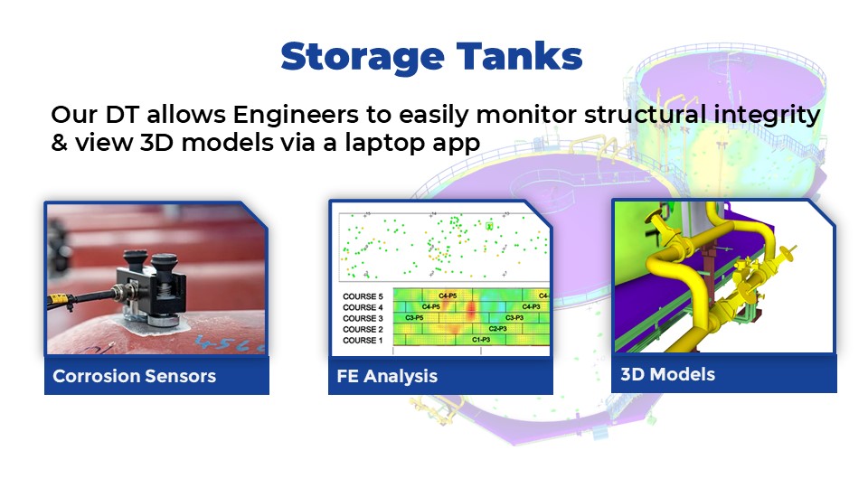
3- Acoustic Emission & Laser Scanning for Tank Analysis / Advance Tank Analysis; Fitness for Service (FFS)
4- Engineering As-built, Design & Analysis
3D Digital Twin Room
Pioneering Digitalizing for Biopharmaceutical Facilities (Vaccine Factory)
Digitalizing Assets to Digital Twin for Health Industry
5- Laser Scan & DC Survey
Desktop DC
PML Laser Scanning, Dimensional Control & Final Element Analysis (FEA)
Submillimeter Survey Valve Flange Face, Orientation and Alignment
Stockpile Measurement Utilizing Digital Data
6- Geographic Information System (GIS)
7- Unmanned Aerial Vehicles (UAV) Photogrammetry
Laser Scanning & Drone for Solar Panel Installation
8- Subsidence Monitoring
9- Soil Investigation
Manual Excavation Trial Dig
Downhole Seismic Test
10- Data Simulation AR/VR
Leveraging Laser Scanning Data to Create Artificial Intelligence (AI) for Corrosion Inspection
11- Accurate As-built & Analysis for Slope Management & River Widening
12- Topographical Survey & Underground Detection Mapping (UDM)
13- Photography & Videography
14- Chemical Services, Support Services & Professional Consultancy
15- Information Technology
16- Logistic & Support Services
Project
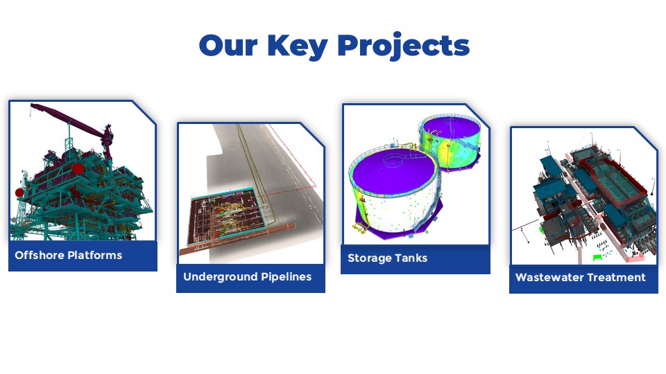
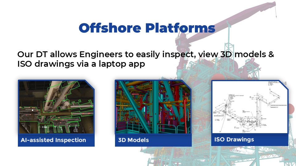
Project Experience
Total Solution / Case Study
Prasarana Digital Solutions
TNF Energy GIS Portal for Energy Assets
Full Technology Hybrid: Laser Scan – Drone – GPS Positioning – 3D Reality (General)
Full Technology Hybrid: Laser Scan – Drone – GPS Positioning – 3D Reality (Admin)
Digital Mapping : 3D Underground Detection Mapping, Topography & Digital Terrain Model
Provision of Engineering FEA for PCE Stack Up Stress Analysis
Canopy Walk, Kuala Tahan
TNF Holistic Proposal For Pipeline Project (EPCIC)
Total Digital Solution for Asset Management Operation & Maintenance for Building
Gallery
IMT-GT REGIONAL BUSINESS EXCELLENCE AWARD 2025 – Scalability and Future Growth Potential under the category of Technology & Digital Transformation Excellence Award
Enterprise 50 (E50) Award 2024 by SME Corp Malaysia
Oil & Gas Asia (OGA) 2022 – OGSE Innovation Awards – iCORD: Artificial Intelligent (AI) to Assist Design, Materials Corrosion Inspection (MCI), HUC Commissioning Works & Asset Integrity Management (AIM)
Oil & Gas Services and Equipment Development Grant for iCORD – Artificial Intelligence (AI) for Corrosion Detection for MCI, HUC, MCM & Design
EIC Reginal Awards Asia Pacific 2023 – Innovation Category
Artificial Intelligence (AI) for MCI Session
The Brand Laureate 2022 Bumiputra Bestbrands Awards
The Brand Laureate 2022 SMEs Bestbrands Awards
SME Corp: Professional Services Score
TNF Annual Iftar & Solat Hajat 2026
TNF Annual Grand Dinner 2021
ANSARA Cycling Ride With ANSARA President
Site Visit Langkawi Century Hotel & Aquabeat Water Theme Park
Research Collaboration between USM and TNF
Speaker for Geological Society of Malaysia Technical Session
ISO 45001:2018
MS ISO 9001:2015
TNF Petaling Jaya Office
TNF Labuan Project Office
TNF Kota Kinabalu Project Office
TNF Bintulu Office
TNF Bangkok, Thailand Office
TNF Songkhla, Thailand Warehouse
Career
Contact Us
ENG
ภาษาไทย
Menu
ENG
ภาษาไทย
6- Geographic Information System (GIS)
Home
»
Services
»
6- Geographic Information System (GIS)
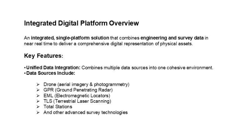
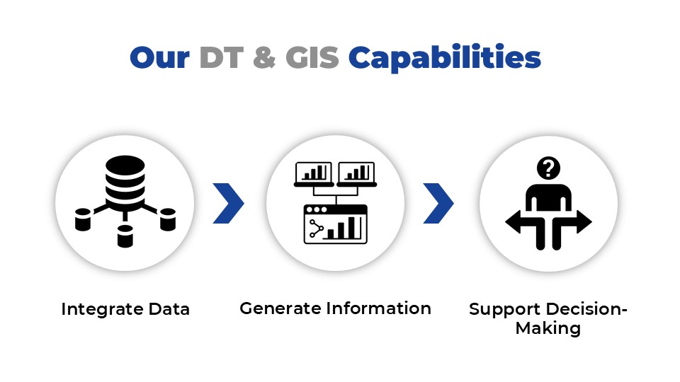
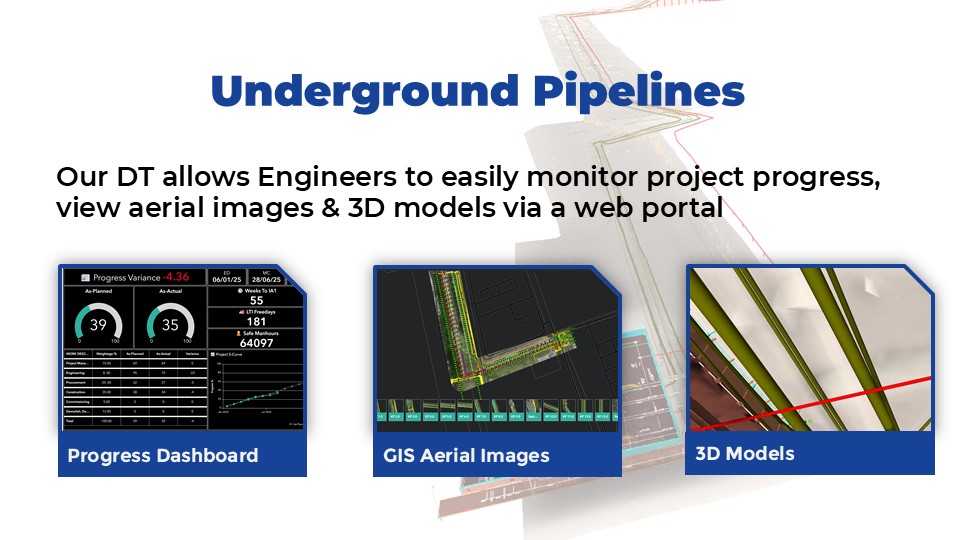
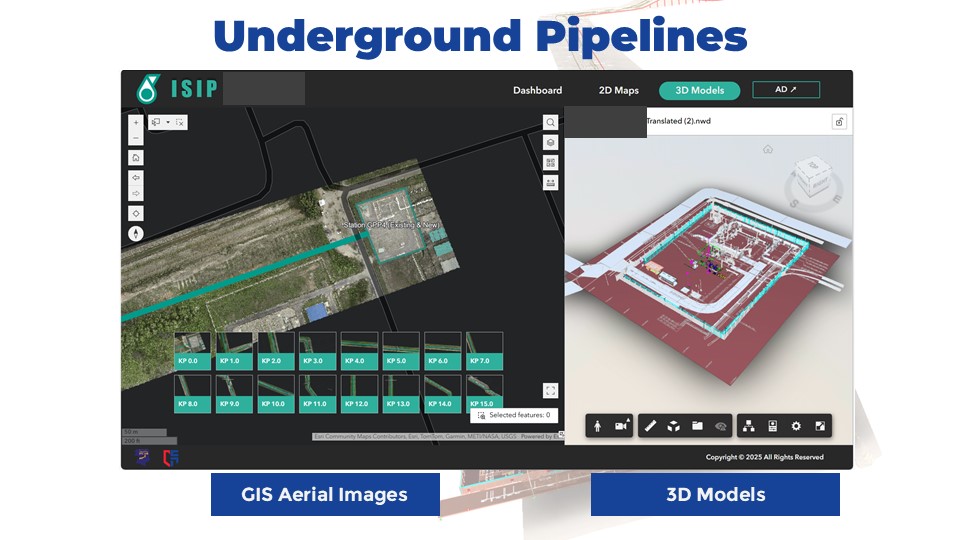
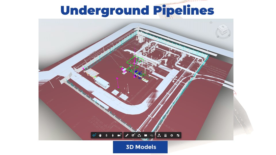
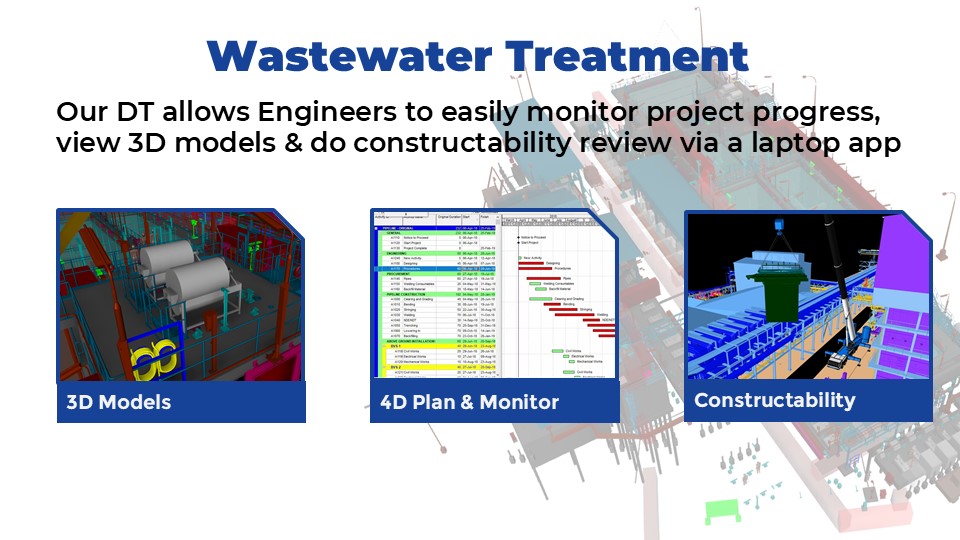
DIGITAL TWINS (DT) & GEOGRAPHIC INFORMATION SYSTEM (GIS)
Home
About Us
Our Team
License
Major Milestones
Services
1- Artificial Intelligence (AI) to assist Material Corrosion Inspection (MCI), Hook Up & Commissioning (HUC) works and Assets Integrity Management (AIM)
2- Reverse Engineering & Building Information Modelling (BIM)
3- Acoustic Emission & Laser Scanning for Tank Analysis / Advance Tank Analysis; Fitness for Service (FFS)
4- Engineering As-built, Design & Analysis
3D Digital Twin Room
Pioneering Digitalizing for Biopharmaceutical Facilities (Vaccine Factory)
Digitalizing Assets to Digital Twin for Health Industry
5- Laser Scan & DC Survey
Desktop DC
PML Laser Scanning, Dimensional Control & Final Element Analysis (FEA)
Submillimeter Survey Valve Flange Face, Orientation and Alignment
Stockpile Measurement Utilizing Digital Data
6- Geographic Information System (GIS)
7- Unmanned Aerial Vehicles (UAV) Photogrammetry
Laser Scanning & Drone for Solar Panel Installation
8- Subsidence Monitoring
9- Soil Investigation
Manual Excavation Trial Dig
Downhole Seismic Test
10- Data Simulation AR/VR
Leveraging Laser Scanning Data to Create Artificial Intelligence (AI) for Corrosion Inspection
11- Accurate As-built & Analysis for Slope Management & River Widening
12- Topographical Survey & Underground Detection Mapping (UDM)
13- Photography & Videography
14- Chemical Services, Support Services & Professional Consultancy
15- Information Technology
16- Logistic & Support Services
Project
Project Experience
Total Solution / Case Study
Prasarana Digital Solutions
TNF Energy GIS Portal for Energy Assets
Full Technology Hybrid: Laser Scan – Drone – GPS Positioning – 3D Reality (General)
Full Technology Hybrid: Laser Scan – Drone – GPS Positioning – 3D Reality (Admin)
Digital Mapping : 3D Underground Detection Mapping, Topography & Digital Terrain Model
Provision of Engineering FEA for PCE Stack Up Stress Analysis
Canopy Walk, Kuala Tahan
TNF Holistic Proposal For Pipeline Project (EPCIC)
Total Digital Solution for Asset Management Operation & Maintenance for Building
Gallery
IMT-GT REGIONAL BUSINESS EXCELLENCE AWARD 2025 – Scalability and Future Growth Potential under the category of Technology & Digital Transformation Excellence Award
Enterprise 50 (E50) Award 2024 by SME Corp Malaysia
Oil & Gas Asia (OGA) 2022 – OGSE Innovation Awards – iCORD: Artificial Intelligent (AI) to Assist Design, Materials Corrosion Inspection (MCI), HUC Commissioning Works & Asset Integrity Management (AIM)
Oil & Gas Services and Equipment Development Grant for iCORD – Artificial Intelligence (AI) for Corrosion Detection for MCI, HUC, MCM & Design
EIC Reginal Awards Asia Pacific 2023 – Innovation Category
Artificial Intelligence (AI) for MCI Session
The Brand Laureate 2022 Bumiputra Bestbrands Awards
The Brand Laureate 2022 SMEs Bestbrands Awards
SME Corp: Professional Services Score
TNF Annual Iftar & Solat Hajat 2026
TNF Annual Grand Dinner 2021
ANSARA Cycling Ride With ANSARA President
Site Visit Langkawi Century Hotel & Aquabeat Water Theme Park
Research Collaboration between USM and TNF
Speaker for Geological Society of Malaysia Technical Session
ISO 45001:2018
MS ISO 9001:2015
TNF Petaling Jaya Office
TNF Labuan Project Office
TNF Kota Kinabalu Project Office
TNF Bintulu Office
TNF Bangkok, Thailand Office
TNF Songkhla, Thailand Warehouse
Career
Contact Us
ENG
ภาษาไทย